Hantavirus Hot Spots in the US: A State-by-State Map
If you're searching for a hantavirus map because you've seen news about an outbreak, here is the straightforward answer: there is no new US outbreak in 2026. The disease remains where it has always been — concentrated in the rural western United States, with the Four Corners region carrying the heaviest historical burden.
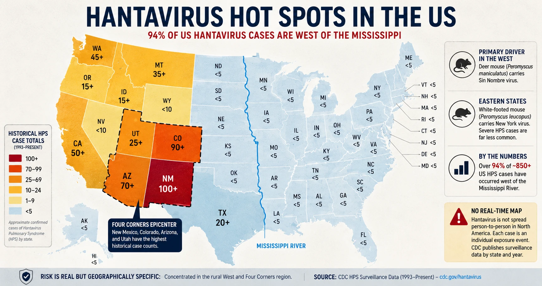
Since CDC surveillance began in 1993, the US has recorded more than 850 confirmed cases of hantavirus pulmonary syndrome (HPS). That works out to roughly 25–30 cases per year on average, though the annual count swings between 15 and 50+ depending on rodent population cycles. Over 94% of those cases occurred west of the Mississippi River. The geography of hantavirus risk in the US has not changed.
The Western US Concentration
The primary driver of North American hantavirus is the deer mouse (Peromyscus maniculatus), which carries Sin Nombre virus. Deer mice are found across North America but reach their highest densities in the shrublands, forests, and grasslands of the West. When human activity — camping, cleaning out sheds, working in barns — disturbs areas where deer mice nest, the risk of inhaling infectious droplets goes up.
The following table shows historical HPS case totals by state based on CDC surveillance data from 1993 through the most recent reporting period.
| State | Approximate Total Cases |
|---|---|
| New Mexico | 100+ |
| Colorado | 90+ |
| Arizona | 70+ |
| California | 50+ |
| Washington | 45+ |
| Montana | 35+ |
| Utah | 25+ |
| Texas | 20+ |
| Oregon | 15+ |
| Idaho | 15+ |
| Other western states | Scattered, single digits to teens |
| All eastern states combined | Fewer than 50 total |
New Mexico's lead is not accidental. The state sits at the center of ideal deer mouse habitat, has high rural land use, and was the site of the first recognized HPS cluster in 1993 — the outbreak that put hantavirus on the public health map in the first place.
Four Corners: The Epicenter
The Four Corners region — where New Mexico, Colorado, Arizona, and Utah meet — is the geographic epicenter of US hantavirus risk. New Mexico and Colorado alone account for nearly 200 confirmed cases, and Arizona adds another 70+.
The 1993 outbreak began here, linked to an unusual surge in deer mouse populations following heavy rainfall. That same dynamic — rain increases vegetation, vegetation increases rodent food supply, rodent populations boom, human-rodent contact rises — still drives case clusters today. The cycle is loosely connected to El Niño years, which bring above-average precipitation to the Southwest.
Elevation matters too. Many cases in this region involve people working or recreating in forested mountain areas between 6,000 and 9,000 feet, where deer mice are abundant and structures like cabins and outbuildings provide ideal nesting sites.
Eastern States on the Map
East of the Mississippi, the risk picture is different in two ways: case counts are far lower, and the primary carrier is not the deer mouse.
In the eastern US, the white-footed mouse (Peromyscus leucopus) is the dominant reservoir. White-footed mice carry New York virus, a hantavirus strain that appears to cause severe HPS far less frequently than Sin Nombre does. The total confirmed HPS case count from all eastern states combined over the full surveillance period is fewer than 50.
This does not mean eastern residents should ignore rodent infestations. Standard precautions — wet-mopping rather than dry-sweeping droppings, wearing gloves and respiratory protection — still apply. The risk is just substantially lower than in the West, and the map reflects that clearly.
Why No Real-Time Map Exists
Several searches around hantavirus reference a "map tracker" or "live outbreak map." No such tool exists for this disease.
Hantavirus pulmonary syndrome is not a rapidly spreading infectious disease like influenza. It does not transmit person-to-person in North America (the Andes strain in South America is the exception). Each case is an individual exposure event, usually isolated to one person who had contact with infected rodents. There is no chain of transmission to track in real time.
The CDC collects and publishes HPS surveillance data by state and by year. That data is updated periodically — not in real time — and is available on the CDC's HPS surveillance page. It is the most accurate source for current case counts.
What's Driving the 2026 Search Spike
Two events explain the surge in hantavirus searches in early 2026.
The first is the Hondius cruise ship outbreak. Passengers on a polar expedition vessel contracted hantavirus in South America. The strain involved was Andes virus — not Sin Nombre, and not a North American strain. The Hondius outbreak does not change the US risk map in any way. It is a geographically separate event involving a different virus carried by different rodents in a different hemisphere.
The second is coverage of the 2025 death of actor Gene Hackman and his wife in New Mexico. Media reports linked the case to hantavirus, drawing significant public attention. New Mexico has historically high case counts, and a high-profile death there prompted people to search for how widespread the risk actually is.
The answer remains the same: risk is real but geographically specific, concentrated in the rural West, and not currently elevated above historical norms.
How to Check Current Data
For the most current confirmed case counts by state and year, use the CDC's official surveillance resources:
- CDC HPS Surveillance Data: cdc.gov/hantavirus — state-by-state case counts updated periodically
- CDC Case Reporting: HPS is a nationally notifiable disease; cases confirmed by state health departments are reported to CDC
State health departments also publish disease surveillance data and may have more recent local information than the federal CDC page. If you are in a high-risk state and have potential exposure concerns, your state health department is the appropriate contact.
Sources & References
- CDC — Centers for Disease Control and Prevention
Hantavirus: Prevention, Symptoms & Control
- cdc.gov — Index
https://www.cdc.gov/hantavirus/php/surveillance/index.html
- WHO — World Health Organization
Hantavirus Disease: Fact Sheet
All health claims on this page are verified against the primary sources listed above. View our Editorial Policy
Frequently Asked Questions
Medical Disclaimer
The information on this page is for educational purposes only and is not medical advice. If you believe you may have been exposed to hantavirus or are experiencing symptoms, contact a qualified healthcare professional or local health authority immediately.